
Make a donation
Gear up for your next adventure:
As an Amazon Associate, this site earns from qualifying purchases at no extra cost to you.
Gaza Strip topographic map
Click on the map to display elevation.
Make a donation
Gear up for your next adventure:
As an Amazon Associate, this site earns from qualifying purchases at no extra cost to you.
Gaza Strip
The topography of the Gaza Strip is dominated by three ridges parallel to the coastline, which consist of Pleistocene-Holocene aged calcareous aeolian (wind deposited) sandstones, locally referred to as "kurkar", intercalated with red-coloured fine grained paleosols, referred to as "hamra". The three ridges are separated by wadis, which are filled with alluvial deposits. The terrain is flat or rolling, with dunes near the coast. The highest point is Abu 'Awdah (Joz Abu 'Auda), at 105 m (344 ft) above sea level.
Make a donation
Gear up for your next adventure:
As an Amazon Associate, this site earns from qualifying purchases at no extra cost to you.
About this map
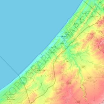
Name: Gaza Strip topographic map, elevation, terrain.
Location: Gaza Strip, Palestinian Territories (31.22013 34.21590 31.59685 34.56732)
Average elevation: 44 m
Minimum elevation: 0 m
Maximum elevation: 170 m
Make a donation
Gear up for your next adventure:
As an Amazon Associate, this site earns from qualifying purchases at no extra cost to you.
Other topographic maps
Click on a map to view its topography, its elevation and its terrain.
Khirbat Abu Falah
Palestinian Territories > Area B
Khirbet Abu Falah is situated in a hilly area in the central highlands of the West Bank and has an average elevation of 743 meters above sea level. It is located 15.7 kilometers northeast of Ramallah. The nearest localities are al-Mazraa al-Sharqiyah to the southwest, Turmus Ayya to the north, al-Mughayyir to…
Average elevation: 758 m
Make a donation
Gear up for your next adventure:
As an Amazon Associate, this site earns from qualifying purchases at no extra cost to you.
Make a donation
Gear up for your next adventure:
As an Amazon Associate, this site earns from qualifying purchases at no extra cost to you.
Qabatiya
Palestinian Territories > Area A
Its entire land area is 50,547 dunams (50.5 km2; 19.5 sq mi), and its elevation is roughly 256 meters (840 feet). Qabatiya is famous for its olive groves, modern agriculture, and limestone industry.
Average elevation: 333 m
Make a donation
Gear up for your next adventure:
As an Amazon Associate, this site earns from qualifying purchases at no extra cost to you.
Mishor Adumim
Palestinian Territories > Judea and Samaria > Area C > Maale Adumim
Average elevation: 265 m
Make a donation
Gear up for your next adventure:
As an Amazon Associate, this site earns from qualifying purchases at no extra cost to you.
Argaman
Palestinian Territories > Judea and Samaria > Area C > Arvot Hayarden Regional Council
Average elevation: -203 m
Nofim
Palestinian Territories > Judea and Samaria > Area C > Shomron Regional Council
Average elevation: 319 m
Make a donation
Gear up for your next adventure:
As an Amazon Associate, this site earns from qualifying purchases at no extra cost to you.
Beit HaArava
Palestinian Territories > Judea and Samaria > Area C > Megilot Yam HaMelakh Regional Council
Average elevation: -294 m
Make a donation
Gear up for your next adventure:
As an Amazon Associate, this site earns from qualifying purchases at no extra cost to you.
Homesh
Palestinian Territories > Judea and Samaria > Area C > Shomron Regional Council
Average elevation: 452 m
Mount of Temptation
Palestinian Territories > Area A
The city of Jericho lies at the feet east of Mount Quruntul, at 258 m (846 ft) below sea level, with the nearby Jordan River and the Dead Sea at even lower elevations, further to the east and southeast. The mount has around 400 m (1,300 ft) of prominence over Jericho, which translates to an elevation of 138 m…
Average elevation: -49 m
Make a donation
Gear up for your next adventure:
As an Amazon Associate, this site earns from qualifying purchases at no extra cost to you.
Fatsael
Palestinian Territories > Judea and Samaria > Area C > Arvot Hayarden Regional Council
Average elevation: -220 m
Nablus
Palestinian Territories > Area A
Insofar as the hilly topography of the site would allow, the city was built on a Roman grid plan and settled with veterans who fought in the victorious legions and other foreign colonists. In the 2nd century CE, Emperor Hadrian built a grand theater in Neapolis that could seat up to 7,000 people. Coins found…
Average elevation: 645 m
Make a donation
Gear up for your next adventure:
As an Amazon Associate, this site earns from qualifying purchases at no extra cost to you.
Ro'i
Palestinian Territories > Judea and Samaria > Area C > Arvot Hayarden Regional Council
Average elevation: 46 m
Make a donation
Gear up for your next adventure:
As an Amazon Associate, this site earns from qualifying purchases at no extra cost to you.
Bethlehem
Palestinian Territories > Area A > Bethlehem
Bethlehem is located at an elevation of about 775 meters (2,543 ft) above sea level, 30 meters (98 ft) higher than nearby Jerusalem. Bethlehem is situated on the Judean Mountains.
Average elevation: 553 m
Hamra
Palestinian Territories > Judea and Samaria > Area C > Arvot Hayarden Regional Council
Average elevation: -57 m
Mehora
Palestinian Territories > Judea and Samaria > Area C > Arvot Hayarden Regional Council
Average elevation: 200 m
Make a donation
Gear up for your next adventure:
As an Amazon Associate, this site earns from qualifying purchases at no extra cost to you.
Sanur
Palestinian Territories > Area A
Sanur is located in the highlands of the northern West Bank. The village is situated on an isolated hilltop along the western edge of the valley and seasonal lake of Marj Sanur, which is named after the village. To the west, Sanur is connected to the Hawarah Ridge of the Zawiya Highlands through a low-lying…
Average elevation: 423 m
Make a donation
Gear up for your next adventure:
As an Amazon Associate, this site earns from qualifying purchases at no extra cost to you.
Bani Naim
Palestinian Territories > Area A
Bani Na'im (Arabic: بني نعيم, romanized: Banī Naʾīm) is a Palestinian town in the southern West Bank located 8 kilometers (5.0 mi) east of Hebron in the Hebron Governorate of the State of Palestine. It is situated at a higher elevation than most localities in the area, with an altitude of 951 meters…
Average elevation: 821 m
Jenin
Palestinian Territories > Area A
Jenin is situated at the foot of the rugged northernmost hills (Jabal Nablus) of the West Bank, and along the southern edge of the Jezreel Valley (Marj Ibn Amer),[65] which the city overlooks.[66] Its highest elevation is about 250 meters above sea level and its lowest areas are 90 meters above sea level.[67]…
Average elevation: 194 m
Make a donation
Gear up for your next adventure:
As an Amazon Associate, this site earns from qualifying purchases at no extra cost to you.
Ramallah
Palestinian Territories > Area A
Ramallah (UK: /rəˈmælə/ rə-MAL-ə, US: /rəˈmɑːlə/ rə-MAH-lə; Arabic: رام الله, romanized: Rām Allāh; IPA: [raːm alˤ.lˤaːh] ; lit. 'God's Height') is a city in the central West Bank, Palestine. It serves as the administrative capital of Palestine, as well as capital of the Ramallah…
Average elevation: 769 m
Make a donation
Gear up for your next adventure:
As an Amazon Associate, this site earns from qualifying purchases at no extra cost to you.
Make a donation
Gear up for your next adventure:
As an Amazon Associate, this site earns from qualifying purchases at no extra cost to you.