
New York County topographic map
Interactive map
Click on the map to display elevation.
About this map
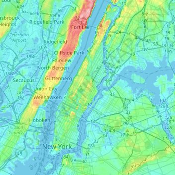
Name: New York County topographic map, elevation, terrain.
Location: New York County, Nueva York, Estados Unidos (40.67932 -74.04722 40.88246 -73.90616)
Average elevation: 16 m
Minimum elevation: -9 m
Maximum elevation: 117 m
Other topographic maps
Click on a map to view its topography, its elevation and its terrain.
Todt Hill
Estados Unidos > Nueva York > Nueva York
Todt Hill, Staten Island, Richmond County, Nueva York, 10304, Estados Unidos
Average elevation: 75 m