
Make a donation
Gear up for your next adventure:
As an Amazon Associate, this site earns from qualifying purchases at no extra cost to you.
Stadtallendorf topographic map
Click on the map to display elevation.
Make a donation
Gear up for your next adventure:
As an Amazon Associate, this site earns from qualifying purchases at no extra cost to you.
Stadtallendorf
Stadtallendorf liegt gemäß der naturräumlichen Gliederung in der westhessischen Senkenzone, die sich in Becken und Schwellen gliedert. Die Stadt liegt diesbezüglich auf der Oberhessischen Schwelle, die das Amöneburger Becken im Westen vom Schwalmbecken im Osten trennt. Auf dieser Schwelle befindet sich auch der Neustädter Sattel, an den der nordöstliche Ortsrand der Stadt stößt; dieser Höhenzug ist ein Teil der Rhein-Weser-Wasserscheide.
Make a donation
Gear up for your next adventure:
As an Amazon Associate, this site earns from qualifying purchases at no extra cost to you.
About this map
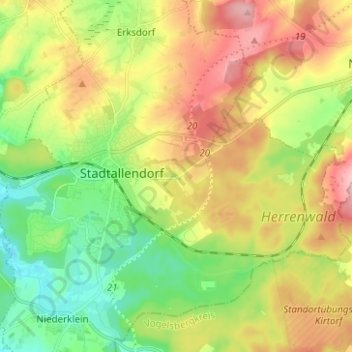
Name: Stadtallendorf topographic map, elevation, terrain.
Average elevation: 270 m
Minimum elevation: 201 m
Maximum elevation: 360 m
Make a donation
Gear up for your next adventure:
As an Amazon Associate, this site earns from qualifying purchases at no extra cost to you.