
Old Beach topographic map
Interactive map
Click on the map to display elevation.
About this map
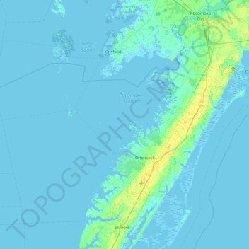
Name: Old Beach topographic map, elevation, terrain.
Location: Old Beach, Accomack County, Virginia, United States (37.47541 -76.13410 38.11541 -75.49410)
Average elevation: 2 m
Minimum elevation: -4 m
Maximum elevation: 23 m
Other topographic maps
Click on a map to view its topography, its elevation and its terrain.
Hacksneck
United States > Virginia > Accomack County
Hacksneck, Accomack County, Virginia, 23358, United States
Average elevation: 1 m
Cheeseman Island
United States > Virginia > Accomack County
Cheeseman Island, Accomack County, Virginia, 21866, United States
Average elevation: 2 m
Painter
United States > Virginia > Accomack County
Painter, Accomack County, Virginia, United States
Average elevation: 10 m
Tangier Island
United States > Virginia > Accomack County > Tangier
Tangier Island, Tangier, Accomack County, Virginia, 23440, United States
Average elevation: 2 m
Deep Creek
United States > Virginia > Accomack County
Deep Creek, Accomack County, Virginia, United States
Average elevation: 1 m
Wishart
United States > Virginia > Accomack County > Wishart
Wishart, Accomack County, Virginia, 23303, United States
Average elevation: 5 m
Herring Island
United States > Virginia > Accomack County
Herring Island, Accomack County, Virginia, United States
Average elevation: 2 m