
Danzig topographic map
Interactive map
Click on the map to display elevation.
About this map
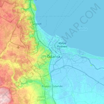
Name: Danzig topographic map, elevation, terrain.
Location: Danzig, Woiwodschaft Pommern, Polen (54.27492 18.42950 54.46645 18.95024)
Average elevation: 59 m
Minimum elevation: -5 m
Maximum elevation: 259 m
Eine Aufteilung in administrative Bezirke gab es in Danzig vor 1939 bzw. 1945 nicht. Zahlreiche Orte, die heute zur Stadt und deren Bezirken gehören, waren in die Kreise Danziger Höhe und Danziger Niederung eingegliedert. Bis 1973 hatte sich das Stadtgebiet durch Eingemeindungen beträchtlich vergrößert.
Other topographic maps
Click on a map to view its topography, its elevation and its terrain.
Waldberg
Polen > Woiwodschaft Pommern > Danzig
Waldberg, Danzig, Woiwodschaft Pommern, 80-281, Polen
Average elevation: 88 m