
Castleton Tower topographic map
Interactive map
Click on the map to display elevation.
About this map
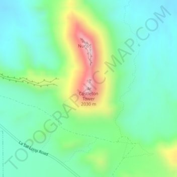
Name: Castleton Tower topographic map, elevation, terrain.
Location: Castleton Tower, Grand County, Utah, United States (38.65122 -109.36795 38.65132 -109.36785)
Average elevation: 1,549 m
Minimum elevation: 1,395 m
Maximum elevation: 1,935 m
Other topographic maps
Click on a map to view its topography, its elevation and its terrain.
Moab
United States > Utah > Grand County
Moab, Grand County, Utah, 84532, United States
Average elevation: 1,357 m
Manns Peak
United States > Utah > Grand County
Manns Peak, Grand County, Utah, United States
Average elevation: 3,427 m
Castle Valley
United States > Utah > Grand County
Castle Valley, Grand County, Utah, United States
Average elevation: 1,610 m
Arches National Park
United States > Utah > Grand County
Arches National Park, Grand County, Utah, United States
Average elevation: 1,476 m