
Thank you for supporting this site ❤️
Make a donation
Make a donation
Gear up for your next adventure:
As an Amazon Associate, this site earns from qualifying purchases at no extra cost to you.
Cugnoli topographic map
Click on the map to display elevation.
Thank you for supporting this site ❤️
Make a donation
Make a donation
Gear up for your next adventure:
As an Amazon Associate, this site earns from qualifying purchases at no extra cost to you.
About this map
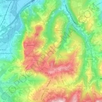
Name: Cugnoli topographic map, elevation, terrain.
Location: Cugnoli, Turrivalignani, Pescara, Abruzzo, 65024, Italy (42.24675 14.01990 42.28675 14.05990)
Average elevation: 203 m
Minimum elevation: 73 m
Maximum elevation: 373 m
Thank you for supporting this site ❤️
Make a donation
Make a donation
Gear up for your next adventure:
As an Amazon Associate, this site earns from qualifying purchases at no extra cost to you.