
Thank you for supporting this site ❤️
Make a donation
Make a donation
Gear up for your next adventure:
As an Amazon Associate, this site earns from qualifying purchases at no extra cost to you.
Ostra topographic map
Click on the map to display elevation.
Thank you for supporting this site ❤️
Make a donation
Make a donation
Gear up for your next adventure:
As an Amazon Associate, this site earns from qualifying purchases at no extra cost to you.
About this map
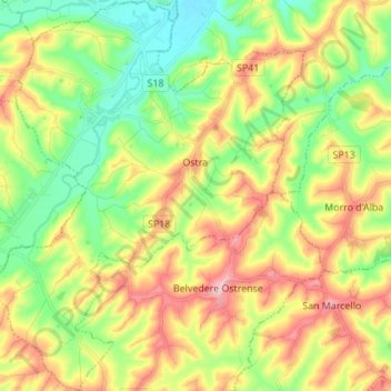
Name: Ostra topographic map, elevation, terrain.
Location: Ostra, Ancona, Marche, Italy (43.55429 13.08304 43.65349 13.19650)
Average elevation: 119 m
Minimum elevation: 26 m
Maximum elevation: 250 m
Thank you for supporting this site ❤️
Make a donation
Make a donation
Gear up for your next adventure:
⌚Altimeter Barometer Watches - Outdoor watches with built-in sensors to track altitude changes and weather shifts
As an Amazon Associate, this site earns from qualifying purchases at no extra cost to you.
Other topographic maps
Click on a map to view its topography, its elevation and its terrain.