
Wichita Falls topographic map
Interactive map
Click on the map to display elevation.
About this map
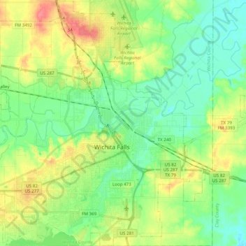
Name: Wichita Falls topographic map, elevation, terrain.
Location: Wichita Falls, Wichita County, Texas, United States (33.83565 -98.61439 33.99641 -98.42435)
Average elevation: 300 m
Minimum elevation: 279 m
Maximum elevation: 336 m
Other topographic maps
Click on a map to view its topography, its elevation and its terrain.
Cashion Community
United States > Texas > Wichita County
Cashion Community, Wichita County, Texas, United States
Average elevation: 310 m
Electra
United States > Texas > Wichita County
Electra, Wichita County, Texas, United States
Average elevation: 362 m
Pleasant Valley
United States > Texas > Wichita County
Pleasant Valley, Wichita County, Texas, United States
Average elevation: 298 m
Haynesville
United States > Texas > Wichita County
Haynesville, Wichita County, Texas, United States
Average elevation: 347 m
Burkburnett
United States > Texas > Wichita County
Burkburnett, Wichita County, Texas, 76354, United States
Average elevation: 315 m
Wichita Falls
United States > Texas > Wichita County
Wichita Falls, Wichita County, Texas, United States
Average elevation: 301 m
Bare Butte
United States > Texas > Wichita County
Bare Butte, Wichita County, Texas, United States
Average elevation: 304 m
Iowa Park
United States > Texas > Wichita County
Iowa Park, Wichita County, Texas, United States
Average elevation: 316 m