
Thank you for supporting this site ❤️
Make a donation
Make a donation
Gear up for your next adventure:
As an Amazon Associate, this site earns from qualifying purchases at no extra cost to you.
Radhanpur topographic map
Click on the map to display elevation.
Thank you for supporting this site ❤️
Make a donation
Make a donation
Gear up for your next adventure:
As an Amazon Associate, this site earns from qualifying purchases at no extra cost to you.
Radhanpur
Radhanpur is located at 23°50′N 71°36′E / 23.83°N 71.6°E / 23.83; 71.6. It has an average elevation of 27 metres (88 feet).
Thank you for supporting this site ❤️
Make a donation
Make a donation
Gear up for your next adventure:
As an Amazon Associate, this site earns from qualifying purchases at no extra cost to you.
About this map
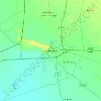
Name: Radhanpur topographic map, elevation, terrain.
Average elevation: 30 m
Minimum elevation: 23 m
Maximum elevation: 41 m
Thank you for supporting this site ❤️
Make a donation
Make a donation
Gear up for your next adventure:
🧦Merino Wool Hiking Socks - Moisture-wicking socks to prevent blisters during long topographic surveys
As an Amazon Associate, this site earns from qualifying purchases at no extra cost to you.