
Make a donation
Gear up for your next adventure:
As an Amazon Associate, this site earns from qualifying purchases at no extra cost to you.
Coalville topographic map
Click on the map to display elevation.
Make a donation
Gear up for your next adventure:
As an Amazon Associate, this site earns from qualifying purchases at no extra cost to you.
Coalville
Coalville has a high-altitude, warm-summer humid continental climate (Köppen Dfb), characterized by extreme diurnal temperature ranges that range from extremely cold winter nights to hot afternoons in the summer. However, the high altitude and low humidity mean that mornings in the summer remain very cool, and frosts have occasionally occurred—even in July. Precipitation is moderate throughout the year, though with a minimum in summer, and snow accumulation is generally heavy due to the very cold nights between November and March, with a median of 60.1 inches (1.53 m) for the year.
Make a donation
Gear up for your next adventure:
As an Amazon Associate, this site earns from qualifying purchases at no extra cost to you.
About this map
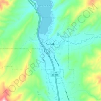
Name: Coalville topographic map, elevation, terrain.
Location: Coalville, Summit County, Utah, United States (40.89002 -111.47093 40.93640 -111.37770)
Average elevation: 1,825 m
Minimum elevation: 1,683 m
Maximum elevation: 2,257 m
Make a donation
Gear up for your next adventure:
As an Amazon Associate, this site earns from qualifying purchases at no extra cost to you.
Other topographic maps
Click on a map to view its topography, its elevation and its terrain.
Make a donation
Gear up for your next adventure:
As an Amazon Associate, this site earns from qualifying purchases at no extra cost to you.
Make a donation
Gear up for your next adventure:
As an Amazon Associate, this site earns from qualifying purchases at no extra cost to you.
Make a donation
Gear up for your next adventure:
As an Amazon Associate, this site earns from qualifying purchases at no extra cost to you.