
Ibarra topographic map
Interactive map
Click on the map to display elevation.
About this map
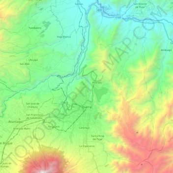
Name: Ibarra topographic map, elevation, terrain.
Location: Ibarra, Imbabura, Équateur (0.26016 -78.17586 0.49989 -78.02502)
Average elevation: 2,398 m
Minimum elevation: 1,487 m
Maximum elevation: 4,534 m
Other topographic maps
Click on a map to view its topography, its elevation and its terrain.
El Rollo
Équateur > Imbabura > Ibarra > Angochagua
El Rollo, Angochagua, Ibarra, Imbabura, 100114, Équateur
Average elevation: 3,152 m
Barrio La Victoria
Équateur > Imbabura > Ibarra > Ibarra
Barrio La Victoria, El Sagrario, Ibarra, Imbabura, 100105, Équateur
Average elevation: 2,275 m