
Ricey-Haut topographic map
Interactive map
Click on the map to display elevation.
About this map
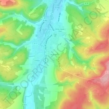
Name: Ricey-Haut topographic map, elevation, terrain.
Average elevation: 237 m
Minimum elevation: 170 m
Maximum elevation: 338 m
Other topographic maps
Click on a map to view its topography, its elevation and its terrain.
Ricey-Haute-Rive
France > Grand Est > Aube > Les Riceys
Ricey-Haute-Rive, Les Riceys, Troyes, Aube, Grand Est, France métropolitaine, 10340, France
Average elevation: 235 m
Ricey-Bas
France > Grand Est > Aube > Les Riceys
Ricey-Bas, Les Riceys, Troyes, Aube, Grand Est, France métropolitaine, 10340, France
Average elevation: 228 m