Downlands topographic map
Interactive map
Click on the map to display elevation.
About this map
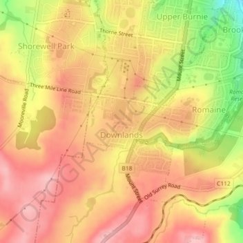
Name: Downlands topographic map, elevation, terrain.
Location: Downlands, Burnie, City of Burnie, Tasmania, Australia (-41.08584 145.88547 -41.07957 145.89669)
Average elevation: 156 m
Minimum elevation: 62 m
Maximum elevation: 207 m
Other topographic maps
Click on a map to view its topography, its elevation and its terrain.
Shorewell Park
Shorewell Park, Burnie, City of Burnie, Tasmania, Australia
Average elevation: 135 m
Emu Heights
Emu Heights, Burnie, City of Burnie, Tasmania, 7320, Australia
Average elevation: 70 m
Upper Burnie
Upper Burnie, Burnie, City of Burnie, Tasmania, 7320, Australia
Average elevation: 111 m
Calder River
Calder River, Burnie, Tasmania, 7320, Australia
Average elevation: 270 m