
Thank you for supporting this site ❤️
Make a donation
Make a donation
Gear up for your next adventure:
As an Amazon Associate, this site earns from qualifying purchases at no extra cost to you.
Cluny topographic map
Click on the map to display elevation.
Thank you for supporting this site ❤️
Make a donation
Make a donation
Gear up for your next adventure:
🐍Australian Snake Bite Kits - Specific pressure immobilization bandages for Australian venomous snakes
As an Amazon Associate, this site earns from qualifying purchases at no extra cost to you.
About this map
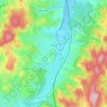
Name: Cluny topographic map, elevation, terrain.
Average elevation: 348 m
Minimum elevation: 225 m
Maximum elevation: 583 m
Thank you for supporting this site ❤️
Make a donation
Make a donation
Gear up for your next adventure:
As an Amazon Associate, this site earns from qualifying purchases at no extra cost to you.
Other topographic maps
Click on a map to view its topography, its elevation and its terrain.
Mont Rachet
France > Bourgogne-Franche-Comté > Saône-et-Loire > La Salle > Mont Rachet
Average elevation: 193 m
Gamay
France > Bourgogne-Franche-Comté > Saône-et-Loire > Saint-Sernin-du-Bois > Gamay
Average elevation: 420 m