
Faringdon topographic map
Click on the map to display elevation.
About this map
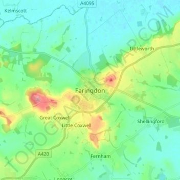
Name: Faringdon topographic map, elevation, terrain.
Average elevation: 92 m
Minimum elevation: 65 m
Maximum elevation: 174 m
Other topographic maps
Click on a map to view its topography, its elevation and its terrain.
The Spinney
United Kingdom > England > Oxfordshire > Vale of White Horse > Kingston Bagpuize
Average elevation: 77 m
Appleford-on-Thames
United Kingdom > England > Oxfordshire > Vale of White Horse
Average elevation: 51 m
Ashdown Park
United Kingdom > England > Oxfordshire > Vale of White Horse > Ashbury
Average elevation: 185 m
Letcombe Bassett
United Kingdom > England > Oxfordshire > Vale of White Horse
Average elevation: 177 m
Wytham Woods
United Kingdom > England > Oxfordshire > Vale of White Horse > Farmoor
Average elevation: 84 m
Botley and North Hinksey
United Kingdom > England > Oxfordshire > Vale of White Horse
Average elevation: 78 m
Radley
United Kingdom > England > Oxfordshire > Vale of White Horse > Abingdon
Average elevation: 66 m
Great Coxwell
United Kingdom > England > Oxfordshire > Vale of White Horse > Faringdon
Average elevation: 108 m
Farmoor Reservoir
United Kingdom > England > Oxfordshire > Vale of White Horse > Cumnor
Average elevation: 69 m
Little Lews
United Kingdom > England > Oxfordshire > Vale of White Horse > Ardington
Average elevation: 183 m
Compton Beauchamp
United Kingdom > England > Oxfordshire > Vale of White Horse
Average elevation: 142 m
Sunningwell
United Kingdom > England > Oxfordshire > Vale of White Horse > Abingdon
Average elevation: 96 m
Stanford in the Vale
United Kingdom > England > Oxfordshire > Vale of White Horse
Average elevation: 79 m
West Challow
United Kingdom > England > Oxfordshire > Vale of White Horse > West Challow
Average elevation: 90 m
Letcombe Regis
United Kingdom > England > Oxfordshire > Vale of White Horse > Letcombe Regis
Average elevation: 167 m
Botley and North Hinksey
United Kingdom > England > Oxfordshire > Vale of White Horse
Average elevation: 78 m
Stanford in the Vale
United Kingdom > England > Oxfordshire > Vale of White Horse
Average elevation: 80 m