
Make a donation
Gear up for your next adventure:
As an Amazon Associate, this site earns from qualifying purchases at no extra cost to you.
Hoggar Mountains topographic map
Click on the map to display elevation.
Make a donation
Gear up for your next adventure:
As an Amazon Associate, this site earns from qualifying purchases at no extra cost to you.
Hoggar Mountains
This mountainous region is located about 1,500 km (930 mi) south of the capital, Algiers. The area is largely rocky desert with an average elevation of more than 900 m (3,000 ft) above sea level. The highest peak, Mount Tahat, is at 2,908 m (9,541 ft). The mountains are primarily composed of metamorphic rock approximately 2 billion years old, although there are areas where more recent volcanic activity has laid down much newer rock. Several of the more dramatic peaks, such as Ilamen, are the result of erosion wearing away extinct volcano domes, leaving behind the more resistant material that plugged the volcanic cones.
Make a donation
Gear up for your next adventure:
As an Amazon Associate, this site earns from qualifying purchases at no extra cost to you.
About this map
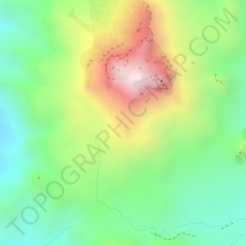
Name: Hoggar Mountains topographic map, elevation, terrain.
Average elevation: 2,451 m
Minimum elevation: 2,151 m
Maximum elevation: 2,879 m
Make a donation
Gear up for your next adventure:
As an Amazon Associate, this site earns from qualifying purchases at no extra cost to you.