Geolocate

Monzone topographic map

Click on the map to display elevation.

About this map

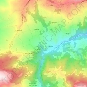
Name: Monzone topographic map, elevation, terrain.

Location: Monzone, Toano, Appennino Reggiano, Reggio nell'Emilia, Emilia-Romagna, Italy (44.33607 10.50784 44.37607 10.54784)

Average elevation: 678 m

Minimum elevation: 416 m

Maximum elevation: 983 m

Other topographic maps

Click on a map to view its topography, its elevation and its terrain.

Bibbiano

Italy > Emilia-Romagna > Reggio nell'Emilia

Average elevation: 106 m

Rubiera

Italy > Emilia-Romagna > Reggio nell'Emilia

Average elevation: 47 m

Villa Minozzo

Italy > Emilia-Romagna > Reggio nell'Emilia

Its territory includes the ski resort of Febbio and the highest peak in the province, Monte Cusna at 2,121 metres (6,959 ft) above sea level. Through the frazione of Civago and the Forbici Pass, elevation 1,574 metres (5,164 ft), the Garfagana can be reached.

Average elevation: 1,001 m

Toano

Italy > Emilia-Romagna > Reggio nell'Emilia

Average elevation: 595 m

Toano

Italy > Emilia-Romagna > Reggio nell'Emilia

Average elevation: 595 m

Gualtieri

Italy > Emilia-Romagna > Reggio nell'Emilia

Average elevation: 22 m

Novellara

Italy > Emilia-Romagna > Reggio nell'Emilia

Average elevation: 23 m

Gear up for your next adventure:

🧭Compass - Navigation compasses for outdoor exploration
🚴Bike GPS - GPS devices for cycling
🍳Ultralight Camping Stoves - Boil water quickly for meals using minimal fuel
🐍Australian Snake Bite Kits - Specific pressure immobilization bandages for Australian venomous snakes
📱Shockproof Phone Cases - Extra protection for your smartphone against drops on rocky terrain

As an Amazon Associate, this site earns from qualifying purchases at no extra cost to you.