
Foz de Iguazú topographic map
Interactive map
Click on the map to display elevation.
About this map
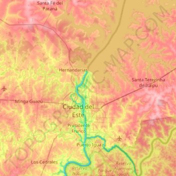
Name: Foz de Iguazú topographic map, elevation, terrain.
Average elevation: 228 m
Minimum elevation: 89 m
Maximum elevation: 355 m
Other topographic maps
Click on a map to view its topography, its elevation and its terrain.
Itaipú
Brasil > PR > Foz de Iguazú
Itaipú, Foz de Iguazú, Microrregião Foz do Iguaçu, Mesorregião Oeste Paranaense, PR, Región Sur, Brasil
Average elevation: 192 m