
Make a donation
Gear up for your next adventure:
As an Amazon Associate, this site earns from qualifying purchases at no extra cost to you.
Evanston topographic map
Click on the map to display elevation.
Make a donation
Gear up for your next adventure:
As an Amazon Associate, this site earns from qualifying purchases at no extra cost to you.
Evanston
Evanston is located at 41°16′5.81″N 110°57′47.65″W / 41.2682806°N 110.9632361°W / 41.2682806; -110.9632361 (41.2682794, -110.9632373). The elevation is 6,749 feet (2,057 m) above sea level.
Make a donation
Gear up for your next adventure:
As an Amazon Associate, this site earns from qualifying purchases at no extra cost to you.
About this map
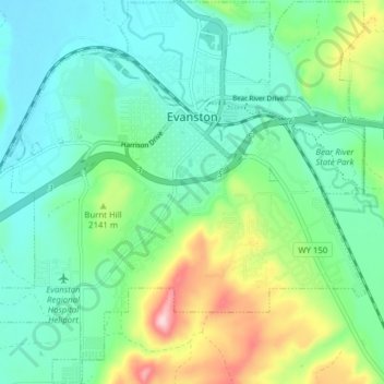
Name: Evanston topographic map, elevation, terrain.
Location: Evanston, Uinta County, Wyoming, United States (41.22750 -111.00557 41.28601 -110.92856)
Average elevation: 2,100 m
Minimum elevation: 2,033 m
Maximum elevation: 2,285 m
Make a donation
Gear up for your next adventure:
As an Amazon Associate, this site earns from qualifying purchases at no extra cost to you.
Other topographic maps
Click on a map to view its topography, its elevation and its terrain.