
Richelle topographic map
Interactive map
Click on the map to display elevation.
About this map
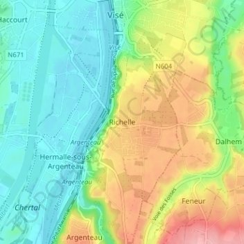
Name: Richelle topographic map, elevation, terrain.
Location: Richelle, Wezet, Luik, Wallonië, 4600, België (50.69714 5.67535 50.73714 5.71535)
Average elevation: 94 m
Minimum elevation: 52 m
Maximum elevation: 166 m
Other topographic maps
Click on a map to view its topography, its elevation and its terrain.
Klein-Ternaaien
Klein-Ternaaien, Wezet, Luik, Wallonië, 4600, België
Average elevation: 68 m