
Honduras topographic map
Interactive map
Click on the map to display elevation.
About this map
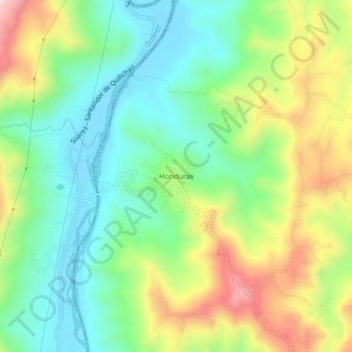
Name: Honduras topographic map, elevation, terrain.
Location: Honduras, Buenos Aires, Norte, Cauca, Colombia (2.97075 -76.69582 3.01075 -76.65582)
Average elevation: 1,154 m
Minimum elevation: 1,005 m
Maximum elevation: 1,413 m
Other topographic maps
Click on a map to view its topography, its elevation and its terrain.
La Balsa
Colombia > Cauca > Buenos Aires > La Balsa
La Balsa, Buenos Aires, Norte, Cauca, Pacífica, Colombia
Average elevation: 1,002 m