
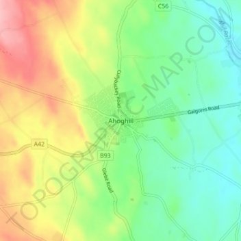
Ahoghill topographic map
Interactive map
Click on the map to display elevation.
About this map
Name: Ahoghill topographic map, elevation, terrain.
Average elevation: 84 m
Minimum elevation: 37 m
Maximum elevation: 157 m
Other topographic maps
Click on a map to view its topography, its elevation and its terrain.
Carrickfergus
United Kingdom > Northern Ireland > County Antrim
Carrickfergus, County Antrim, Ulster, Northern Ireland, BT38 7AF, United Kingdom
Average elevation: 49 m
Portrush
United Kingdom > Northern Ireland > County Antrim
Portrush, County Antrim, Ulster, Northern Ireland, BT56 8BN, United Kingdom
Average elevation: 23 m
Ballymena
United Kingdom > Northern Ireland > County Antrim
Ballymena, County Antrim, Northern Ireland, BT43 6DT, United Kingdom
Average elevation: 74 m
Larne
United Kingdom > Northern Ireland > County Antrim
Larne, County Antrim, Northern Ireland, BT40 1JS, United Kingdom
Average elevation: 54 m
Belfast
United Kingdom > Northern Ireland > County Antrim
Belfast, County Antrim, Ulster, Northern Ireland, BT1 5GS, United Kingdom
Average elevation: 87 m
Antrim
United Kingdom > Northern Ireland > County Antrim
Antrim, County Antrim, Northern Ireland, BT41 4AR, United Kingdom
Average elevation: 50 m