
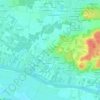
Les Caves aux Fièvres topographic map
Interactive map
Click on the map to display elevation.
About this map
Name: Les Caves aux Fièvres topographic map, elevation, terrain.
Average elevation: 38 m
Minimum elevation: 25 m
Maximum elevation: 83 m
Other topographic maps
Click on a map to view its topography, its elevation and its terrain.
La Meslaie
France > Centre-Val de Loire > Indre-et-Loire > Beaumont-en-Véron
La Meslaie, Beaumont-en-Véron, Chinon, Indre-et-Loire, Centre-Val de Loire, France métropolitaine, 37420, France
Average elevation: 51 m
Le Bourg
France > Centre-Val de Loire > Indre-et-Loire > Beaumont-en-Véron
Le Bourg, Beaumont-en-Véron, Chinon, Indre-et-Loire, Centre-Val de Loire, France métropolitaine, 37420, France
Average elevation: 44 m
Les Baffes
France > Centre-Val de Loire > Indre-et-Loire > Beaumont-en-Véron
Les Baffes, Beaumont-en-Véron, Chinon, Indre-et-Loire, Centre-Val de Loire, France métropolitaine, 37420, France
Average elevation: 46 m
La Haute Rue
France > Centre-Val de Loire > Indre-et-Loire > Beaumont-en-Véron > La Haute Rue
La Haute Rue, Beaumont-en-Véron, Chinon, Indre-et-Loire, Centre-Val de Loire, France métropolitaine, 37420, France
Average elevation: 40 m