
Make a donation
Gear up for your next adventure:
As an Amazon Associate, this site earns from qualifying purchases at no extra cost to you.
Adana topographic map
Click on the map to display elevation.
Make a donation
Gear up for your next adventure:
As an Amazon Associate, this site earns from qualifying purchases at no extra cost to you.
Adana
Adana is located on the 37th parallel north at the northeastern edge of the Mediterranean, where it serves as the gateway to the Cilicia plain. This large stretch of flat, fertile land lies southeast of the Taurus Mountains. From Adana, crossing Cilicia westwards, the road from Tarsus enters the foothills of the Taurus Mountains, eventually reaching an altitude of nearly 4,000 feet (1,200 m). It goes through the famous Cilician Gates, the rocky pass through which armies have coursed since the dawn of history, and continues to the Anatolian plain.
Make a donation
Gear up for your next adventure:
As an Amazon Associate, this site earns from qualifying purchases at no extra cost to you.
About this map
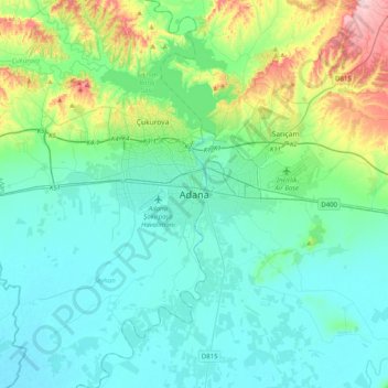
Name: Adana topographic map, elevation, terrain.
Location: Adana, Seyhan, Adana, Mediterranean Region, 01060, Turkey (36.82636 35.16529 37.14636 35.48529)
Average elevation: 61 m
Minimum elevation: 3 m
Maximum elevation: 312 m
Make a donation
Gear up for your next adventure:
As an Amazon Associate, this site earns from qualifying purchases at no extra cost to you.
Other topographic maps
Click on a map to view its topography, its elevation and its terrain.