Geolocate

Menheniot topographic map

Click on the map to display elevation.

About this map

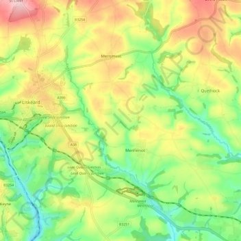
Name: Menheniot topographic map, elevation, terrain.

Location: Menheniot, Cornwall, England, United Kingdom (50.41197 -4.46695 50.48579 -4.34979)

Average elevation: 109 m

Minimum elevation: 18 m

Maximum elevation: 228 m

Gear up for your next adventure:

📍Handheld GPS - GPS devices for hiking and navigation
🪢550 Survival Paracord - Versatile cordage for gear repair and emergency lashing
🐍Snake Gaiters - Protection against snake bites
🔥Camping Stoves - Portable stoves for outdoor cooking
🥾Hiking Gaiters - Leg protection for trails

As an Amazon Associate, this site earns from qualifying purchases at no extra cost to you.