Geolocate

Valinhos topographic map

Click on the map to display elevation.

Valinhos

Valinhos (Portuguese pronunciation: ) is a municipality (município) in the state of São Paulo, Brazil. It is the birthplace of Adoniran Barbosa. Valinhos is famous for its purple fig, the theme of its annual Fig Fest. It is part of the Metropolitan Region of Campinas. The population is 131,210 (as of 2020) in an area of 148.54 square kilometres (57.35 square miles). Its elevation is 660 m (2,165.35 ft). Its name means 'little valleys' in Portuguese.

About this map
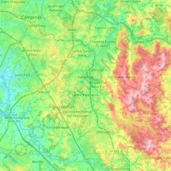
Name: Valinhos topographic map, elevation, terrain.

Location: Valinhos, Região Imediata de Campinas, Região Metropolitana de Campinas, Região Geográfica Intermediária de Campinas, São Paulo, Southeast Region, Brazil (-23.05646 -47.07529 -22.90309 -46.87453)

Average elevation: 729 m

Minimum elevation: 580 m

Maximum elevation: 979 m

Gear up for your next adventure:

🔋Solar Power Banks - Solar chargers for outdoors
🧦Hiking Socks - Comfortable socks for long hikes
🧼Biodegradable Outdoor Soap - Clean gear and yourself without harming the local ecosystem
🎧Bluetooth Outdoor Earbuds - Listen to navigation cues or podcasts during long solo treks
📖Australian Bush Survival Books - Local knowledge on finding water and surviving the outback

As an Amazon Associate, this site earns from qualifying purchases at no extra cost to you.