
Hof Perlberg topographic map
Interactive map
Click on the map to display elevation.
About this map
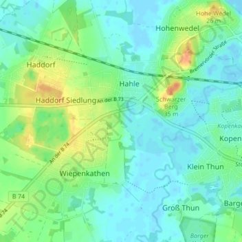
Name: Hof Perlberg topographic map, elevation, terrain.
Average elevation: 11 m
Minimum elevation: -2 m
Maximum elevation: 36 m
Other topographic maps
Click on a map to view its topography, its elevation and its terrain.
Bützflethermoor
Deutschland > Niedersachsen > Landkreis Stade > Stade
Bützflethermoor, Stade, Landkreis Stade, Niedersachsen, 21683, Deutschland
Average elevation: 0 m