
Dundas topographic map
Click on the map to display elevation.
Dundas
Dundas /ˈdʌnˌdæs/ is a community and former town in Hamilton, Ontario, Canada. It is nicknamed the Valley Town because of its topographical location at the bottom of the Niagara Escarpment on the western edge of Lake Ontario. The population has been stable for decades at about twenty thousand, largely because it has not annexed rural land from the protected Dundas Valley Conservation Area.
About this map
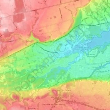
Name: Dundas topographic map, elevation, terrain.
Location: Dundas, Hamilton, Golden Horseshoe, Ontario, L9H 1T5, Canada (43.22619 -79.99463 43.30619 -79.91463)
Average elevation: 171 m
Minimum elevation: 72 m
Maximum elevation: 273 m