
Bujumbura Mairie topographic map
Interactive map
Click on the map to display elevation.
About this map
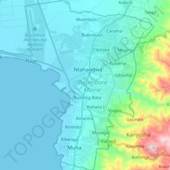
Name: Bujumbura Mairie topographic map, elevation, terrain.
Location: Bujumbura Mairie, Burundi (-3.44496 29.28880 -3.30012 29.42182)
Average elevation: 907 m
Minimum elevation: 766 m
Maximum elevation: 1,801 m
Other topographic maps
Click on a map to view its topography, its elevation and its terrain.