
Putumayo topographic map
Interactive map
Click on the map to display elevation.
About this map
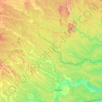
Name: Putumayo topographic map, elevation, terrain.
Location: Putumayo, Loreto, Peru (-3.42422 -75.61553 -0.03928 -70.05883)
Average elevation: 163 m
Minimum elevation: 68 m
Maximum elevation: 624 m
Other topographic maps
Click on a map to view its topography, its elevation and its terrain.
Santa Fe
Peru > Loreto > Emilio San Martín
Santa Fe, Emilio San Martín, Province of Requena, Loreto, Peru
Average elevation: 103 m
Concesión para Conservación Amazon Rainforest
Concesión para Conservación Amazon Rainforest, Province of Requena, Loreto, 065, Peru
Average elevation: 103 m
Colonia
Peru > Loreto > Las Amazonas
Colonia, Las Amazonas, Province of Maynas, Loreto, Peru
Average elevation: 81 m