
Make a donation
Gear up for your next adventure:
As an Amazon Associate, this site earns from qualifying purchases at no extra cost to you.
Cerrito topographic map
Click on the map to display elevation.
Make a donation
Gear up for your next adventure:
As an Amazon Associate, this site earns from qualifying purchases at no extra cost to you.
About this map
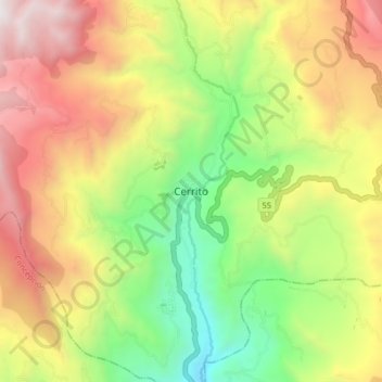
Name: Cerrito topographic map, elevation, terrain.
Average elevation: 3,030 m
Minimum elevation: 2,168 m
Maximum elevation: 4,030 m
Make a donation
Gear up for your next adventure:
As an Amazon Associate, this site earns from qualifying purchases at no extra cost to you.
Other topographic maps
Click on a map to view its topography, its elevation and its terrain.
Vetas
Vetas es un municipio del departamento de Santander, Colombia y forma parte de la provincia de Soto Norte. Es una de las localidades más antigua de Santander, ya que su fundación —ocasionada por su riqueza aurífera— se realizó en la etapa inicial de la conquista española. Es el municipio más alto del…
Average elevation: 3,471 m
San Gil
La mayor parte del territorio varía de ondulado a fuertemente ondulado y su relieve corresponde a la cordillera Oriental andina. Sus montañas se levantan al norte hasta el alto de la Legua y sigue elevándose hasta los pozos donde se halla el aeropuerto a una altitud de 1750 metros. Por el oriente se levanta…
Average elevation: 1,505 m