
Make a donation
Gear up for your next adventure:
As an Amazon Associate, this site earns from qualifying purchases at no extra cost to you.
Warminster topographic map
Click on the map to display elevation.
Make a donation
Gear up for your next adventure:
As an Amazon Associate, this site earns from qualifying purchases at no extra cost to you.
Warminster
Warminster Town Hall, at the junction of the High Street and Weymouth Street, was designed c. 1837 by Edward Blore at the expense of the 5th Marquess of Bath; the two-storey front elevation is a replica of Longleat, with the addition of a central bellcote, clock and coat of arms.[32] The building was sold by the district council in 1979.[33]
Make a donation
Gear up for your next adventure:
As an Amazon Associate, this site earns from qualifying purchases at no extra cost to you.
About this map
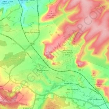
Name: Warminster topographic map, elevation, terrain.
Location: Warminster, Wiltshire, England, United Kingdom (51.18948 -2.22830 51.24075 -2.11980)
Average elevation: 143 m
Minimum elevation: 70 m
Maximum elevation: 215 m
Make a donation
Gear up for your next adventure:
As an Amazon Associate, this site earns from qualifying purchases at no extra cost to you.
Other topographic maps
Click on a map to view its topography, its elevation and its terrain.
Make a donation
Gear up for your next adventure:
As an Amazon Associate, this site earns from qualifying purchases at no extra cost to you.
Make a donation
Gear up for your next adventure:
As an Amazon Associate, this site earns from qualifying purchases at no extra cost to you.