Geolocate

Tisbury topographic map

Click on the map to display elevation.

About this map

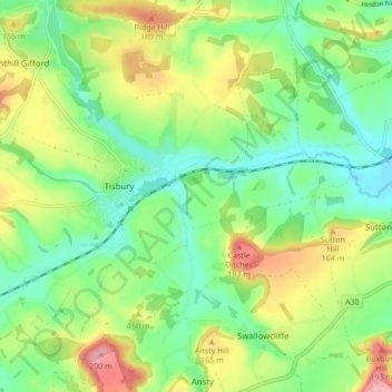
Name: Tisbury topographic map, elevation, terrain.

Location: Tisbury, Wiltshire, England, United Kingdom (51.03566 -2.11324 51.08981 -2.04207)

Average elevation: 127 m

Minimum elevation: 78 m

Maximum elevation: 210 m

Gear up for your next adventure:

🐍Snake Gaiters - Protection against snake bites
🥾Trail Running Shoes - Shoes for trail running
🧥Packable Rain Jackets - Breathable waterproof layers for unpredictable mountain weather
📻Handheld UHF Radios - Critical communication for groups in the Australian outback
🎒3L Hydration Reservoirs - Hands-free drinking to stay hydrated on steep contour climbs

As an Amazon Associate, this site earns from qualifying purchases at no extra cost to you.