Geolocate

Parksville topographic map

Click on the map to display elevation.

About this map

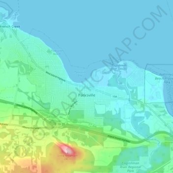
Name: Parksville topographic map, elevation, terrain.

Location: Parksville, Regional District of Nanaimo, British Columbia, Canada (49.29765 -124.35307 49.34498 -124.24393)

Average elevation: 38 m

Minimum elevation: -1 m

Maximum elevation: 240 m

Other topographic maps

Click on a map to view its topography, its elevation and its terrain.

Gear up for your next adventure:

📸Action Cameras - Record your journey across interesting topographic features in 4K
📻Handheld UHF Radios - Critical communication for groups in the Australian outback
🥶Thermal Beanies - Warm hats for cold hikes
🧼Clip-on Hand Sanitizer - Maintain hygiene when water for washing is scarce
📱Tablet Tripod Mounts - Steady platforms for viewing digital maps or taking long exposures

As an Amazon Associate, this site earns from qualifying purchases at no extra cost to you.