Geolocate
👉 Easily get elevation data in JSON, GeoTIFF and KML formats using Elevation API
Thank you for supporting this site ❤️
Make a donation

Brossard topographic map

Click on the map to display elevation.

👉 Easily get elevation data in JSON, GeoTIFF and KML formats using Elevation API
Thank you for supporting this site ❤️
Make a donation

About this map

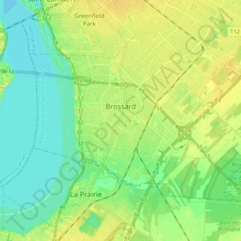
Name: Brossard topographic map, elevation, terrain.

Location: Brossard, Urban agglomeration of Longueuil, Montérégie, Quebec, Canada (45.41309 -73.52970 45.48561 -73.37637)

Average elevation: 17 m

Minimum elevation: 4 m

Maximum elevation: 37 m

Other topographic maps

Click on a map to view its topography, its elevation and its terrain.

Gear up for your next adventure:

📖Australian Bush Survival Books - Local knowledge on finding water and surviving the outback
👟Lightweight Trail Runners - Agile footwear for fast movement over rugged Australian terrain
🍳Ultralight Camping Stoves - Boil water quickly for meals using minimal fuel
🔥Ferrocerium Rod Fire Starters - Reliable fire lighting in wet or windy conditions without matches
📚Map Reading & Navigation Guides - Master the art of interpreting topographic contours and symbols

As an Amazon Associate, this site earns from qualifying purchases at no extra cost to you.