
Bayhaven topographic map
Click on the map to display elevation.
About this map
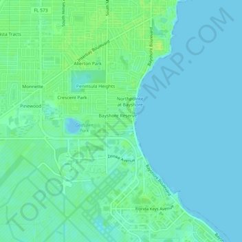
Name: Bayhaven topographic map, elevation, terrain.
Average elevation: 5 m
Minimum elevation: -3 m
Maximum elevation: 13 m
Other topographic maps
Click on a map to view its topography, its elevation and its terrain.
Lutz
United States > Florida > Hillsborough County > Tampa
Lutz is characterized by a gently rolling topography that showcases the distinctive features of the central Florida landscape. The area has an average elevation of about 70 feet (21 meters) above sea level, contributing to its mild undulations rather than dramatic elevation changes. The terrain is marked by a…
Average elevation: 20 m
Carrollwood
United States > Florida > Hillsborough County > Tampa
Carrollwood is located at 28.1 degrees north, 82.5 degrees west (28.0523, -82.4858). The elevation for the community is 39 feet (12 m) above sea level.
Average elevation: 16 m
Carrollwood
United States > Florida > Hillsborough County > Tampa
Carrollwood is located at 28.1 degrees north, 82.5 degrees west (28.0523, -82.4858). The elevation for the community is 39 feet (12 m) above sea level.
Average elevation: 16 m
Carrollwood
United States > Florida > Hillsborough County > Tampa
Carrollwood is located at 28.1 degrees north, 82.5 degrees west (28.0523, -82.4858). The elevation for the community is 39 feet (12 m) above sea level.
Average elevation: 16 m