
Fujieda topographic map
Interactive map
Click on the map to display elevation.
About this map
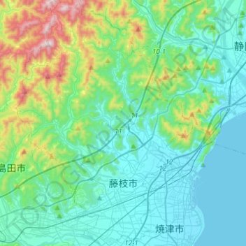
Name: Fujieda topographic map, elevation, terrain.
Location: Fujieda, Préfecture de Shizuoka, Chūbu, Japon (34.81581 138.15167 35.01571 138.32749)
Average elevation: 164 m
Minimum elevation: 0 m
Maximum elevation: 846 m
Other topographic maps
Click on a map to view its topography, its elevation and its terrain.