Geolocate

Vina topographic map

Click on the map to display elevation.

About this map

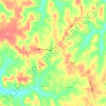
Name: Vina topographic map, elevation, terrain.

Location: Vina, Franklin County, Alabama, 35593, United States (34.35962 -88.09164 34.39046 -88.03589)

Average elevation: 211 m

Minimum elevation: 171 m

Maximum elevation: 244 m

Other topographic maps

Click on a map to view its topography, its elevation and its terrain.

Union

United States > Alabama > Franklin County

Average elevation: 301 m

Bear Creek

United States > Alabama > Franklin County > Red Bay

Average elevation: 191 m

Liberty Hill

United States > Alabama > Franklin County

Average elevation: 283 m

Gear up for your next adventure:

🦯Adjustable Trekking Poles - Reduce impact on knees when descending steep topographic ridges
💧Personal Water Filters - Drink safely from streams and lakes identified on your map
🔥Camping Stoves - Portable stoves for outdoor cooking
Altimeter Barometer Watches - Outdoor watches with built-in sensors to track altitude changes and weather shifts
👟Lightweight Trail Runners - Agile footwear for fast movement over rugged Australian terrain

As an Amazon Associate, this site earns from qualifying purchases at no extra cost to you.