
Castelo Velho topographic map
Interactive map
Click on the map to display elevation.
About this map
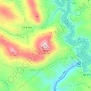
Name: Castelo Velho topographic map, elevation, terrain.
Location: Castelo Velho, Mação, Santarém, 6120-069, Portugal (39.57029 -7.82606 39.57039 -7.82596)
Average elevation: 206 m
Minimum elevation: 57 m
Maximum elevation: 427 m
Other topographic maps
Click on a map to view its topography, its elevation and its terrain.
Chão de Lopes Pequeno
Portugal > Santarém > Mação > Amêndoa
Chão de Lopes Pequeno, Amêndoa, Mação, Santarém, Portugal
Average elevation: 376 m
Pêro Gonçalves
Pêro Gonçalves, Amêndoa, Mação, Santarém, Portugal
Average elevation: 355 m