
Make a donation
Gear up for your next adventure:
As an Amazon Associate, this site earns from qualifying purchases at no extra cost to you.
Quepem topographic map
Click on the map to display elevation.
Make a donation
Gear up for your next adventure:
As an Amazon Associate, this site earns from qualifying purchases at no extra cost to you.
Quepem
Quepem has an average elevation of 21 metres (69 feet). It is located on the bank of River Kushawati. Curchorem and Sanvordem are the major towns located near the Quepem town.
Make a donation
Gear up for your next adventure:
As an Amazon Associate, this site earns from qualifying purchases at no extra cost to you.
About this map
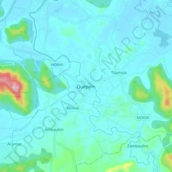
Name: Quepem topographic map, elevation, terrain.
Location: Quepem, South Goa, Goa, 403705, India (15.17425 74.03078 15.25425 74.11078)
Average elevation: 41 m
Minimum elevation: 0 m
Maximum elevation: 338 m
Make a donation
Gear up for your next adventure:
As an Amazon Associate, this site earns from qualifying purchases at no extra cost to you.