
Bizory topographic map
Interactive map
Click on the map to display elevation.
About this map
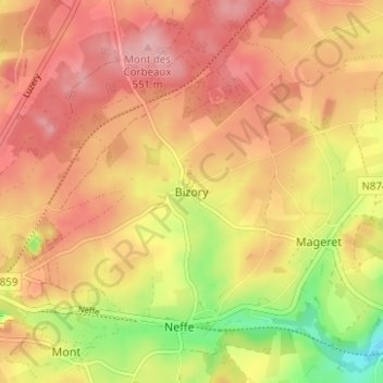
Name: Bizory topographic map, elevation, terrain.
Location: Bizory, Bastenaken, Luxemburg, Wallonië, 6600, België (49.99957 5.74432 50.03957 5.78432)
Average elevation: 501 m
Minimum elevation: 413 m
Maximum elevation: 555 m
Other topographic maps
Click on a map to view its topography, its elevation and its terrain.
Benonchamps
België > Luxemburg > Bastenaken > Bastenaken
Benonchamps, Bastenaken, Luxemburg, Wallonië, België
Average elevation: 462 m
Bastenaken
België > Luxemburg > Bastenaken > Bastenaken
Bastenaken, Luxemburg, Wallonië, 6600, België
Average elevation: 505 m
Moinet
België > Luxemburg > Bastenaken > Bastenaken
Moinet, Bastenaken, Luxemburg, Wallonië, België
Average elevation: 485 m
Lutrebois
België > Luxemburg > Bastenaken > Bastenaken
Lutrebois, Bastenaken, Luxemburg, Wallonië, 6600, België
Average elevation: 504 m