
Río Cauca topographic map
Interactive map
Click on the map to display elevation.
About this map
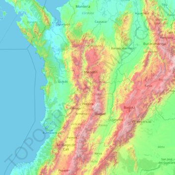
Name: Río Cauca topographic map, elevation, terrain.
Location: Río Cauca, Anserma, Bajo Occidente, Caldas, 76001000, Colombia (2.17813 -76.77886 8.89238 -74.45369)
Average elevation: 764 m
Minimum elevation: -3 m
Maximum elevation: 5,140 m
Other topographic maps
Click on a map to view its topography, its elevation and its terrain.
San Lázaro
San Lázaro, Anserma, Bajo Occidente, Caldas, Colombia
Average elevation: 1,172 m