
Werm topographic map
Interactive map
Click on the map to display elevation.
About this map
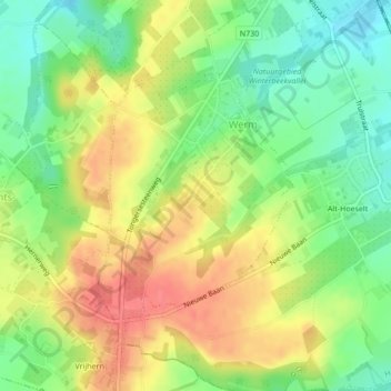
Name: Werm topographic map, elevation, terrain.
Location: Werm, Hoeselt, Tongeren, Limburg, België (50.81995 5.46460 50.83732 5.48605)
Average elevation: 92 m
Minimum elevation: 61 m
Maximum elevation: 124 m
Werm ligt in vochtig-Haspengouw en de hoogte varieert tussen 78 en 122 meter. Te Werm ontspringt de Wermbeek, welke in noordoostelijke richting naar Hoeselt stroomt, waar ze in de Demer uitmondt.
Other topographic maps
Click on a map to view its topography, its elevation and its terrain.
Alt-Hoeselt
België > Limburg > Tongeren > Hoeselt
Alt-Hoeselt, Hoeselt, Tongeren, Limburg, 3730, België
Average elevation: 85 m
Sint-Huibrechts-Hern
België > Limburg > Tongeren > Hoeselt
Sint-Huibrechts-Hern, Hoeselt, Tongeren, Limburg, Vlaanderen, België
Average elevation: 91 m