
Make a donation
Gear up for your next adventure:
As an Amazon Associate, this site earns from qualifying purchases at no extra cost to you.
Épagny topographic map
Click on the map to display elevation.
Make a donation
Gear up for your next adventure:
As an Amazon Associate, this site earns from qualifying purchases at no extra cost to you.
Épagny
Épagny, d'une altitude moyenne de 455 m, est située dans les Préalpes, à environ 5 km à vol d'oiseau au nord-ouest de la ville d'Annecy. C'est pour l'essentiel une vallée glaciaire bordée au sud par le Nant de Gillon (affluent du Fier) et dominée au nord-ouest par la montagne de la Mandallaz.
Make a donation
Gear up for your next adventure:
As an Amazon Associate, this site earns from qualifying purchases at no extra cost to you.
About this map
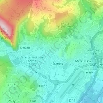
Name: Épagny topographic map, elevation, terrain.
Average elevation: 538 m
Minimum elevation: 421 m
Maximum elevation: 880 m
Make a donation
Gear up for your next adventure:
As an Amazon Associate, this site earns from qualifying purchases at no extra cost to you.
Other topographic maps
Click on a map to view its topography, its elevation and its terrain.
Sur les Nants
France > Auvergne-Rhône-Alpes > Haute-Savoie > Épagny Metz-Tessy
Average elevation: 523 m
La Villa Trévi
France > Auvergne-Rhône-Alpes > Haute-Savoie > Épagny Metz-Tessy
Average elevation: 493 m
Chez Moutier
France > Auvergne-Rhône-Alpes > Haute-Savoie > Épagny Metz-Tessy
Average elevation: 552 m
Make a donation
Gear up for your next adventure:
As an Amazon Associate, this site earns from qualifying purchases at no extra cost to you.
Le Blanc Chat
France > Auvergne-Rhône-Alpes > Haute-Savoie > Épagny Metz-Tessy
Average elevation: 487 m