Geolocate

Attappadi topographic map

Click on the map to display elevation.

About this map

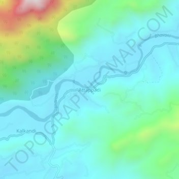
Name: Attappadi topographic map, elevation, terrain.

Location: Attappadi, Mannarkad, Palakkad, Kerala, 678589, India (11.05506 76.54552 11.09506 76.58552)

Average elevation: 677 m

Minimum elevation: 513 m

Maximum elevation: 1,364 m

Other topographic maps

Click on a map to view its topography, its elevation and its terrain.

Thachanattukara

India > Kerala > Mannarkad > Thachanatukkara

Average elevation: 71 m

Gear up for your next adventure:

🩹Blister Prevention Tape - Apply to friction points before they become painful sores
🍴Titanium Spork & Cutlery - Indestructible and feather-light eating utensils
🌬️Windbreaker Jackets - Wind protection jackets
🍶Collapsible Water Bottles - Save space in your pack as you consume your water supply
🔪Camping Knives - Multi-purpose outdoor knives

As an Amazon Associate, this site earns from qualifying purchases at no extra cost to you.