
Harhoura topographic map
Interactive map
Click on the map to display elevation.
About this map
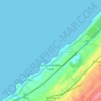
Name: Harhoura topographic map, elevation, terrain.
Average elevation: 16 m
Minimum elevation: -5 m
Maximum elevation: 104 m
Other topographic maps
Click on a map to view its topography, its elevation and its terrain.
Plage Sid El Abed
Maroc > Pachalik de Harhoura > Harhoura
Plage Sid El Abed, Harhoura, Pachalik de Harhoura, Préfecture de Skhirate-Témara, Rabat-Salé-Kénitra, Maroc
Average elevation: 8 m