
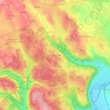
Mas de Vernhet topographic map
Interactive map
Click on the map to display elevation.
About this map
Name: Mas de Vernhet topographic map, elevation, terrain.
Average elevation: 340 m
Minimum elevation: 240 m
Maximum elevation: 406 m
Other topographic maps
Click on a map to view its topography, its elevation and its terrain.
12200
France > Occitanie > Aveyron > Villefranche-de-Rouergue
12200, Villefranche-de-Rouergue, Aveyron, Occitanie, France métropolitaine, France
Average elevation: 360 m
Les Imberts Hauts
France > Occitanie > Aveyron > Villefranche-de-Rouergue
Les Imberts Hauts, Villefranche-de-Rouergue, Aveyron, Occitanie, France métropolitaine, 12200, France
Average elevation: 325 m
Mas de Bonnet
France > Occitanie > Aveyron > Villefranche-de-Rouergue
Mas de Bonnet, Villefranche-de-Rouergue, Aveyron, Occitanie, France métropolitaine, 12200, France
Average elevation: 322 m
Les Ruelles
France > Occitanie > Aveyron > Villefranche-de-Rouergue
Les Ruelles, Villefranche-de-Rouergue, Aveyron, Occitanie, France métropolitaine, 12200, France
Average elevation: 327 m
Mas de Rivals
France > Occitanie > Aveyron > Villefranche-de-Rouergue
Mas de Rivals, Villefranche-de-Rouergue, Aveyron, Occitanie, France métropolitaine, 12200, France
Average elevation: 326 m