
Thank you for supporting this site ❤️
Make a donation
Make a donation
Gear up for your next adventure:
As an Amazon Associate, this site earns from qualifying purchases at no extra cost to you.
Eysins topographic map
Click on the map to display elevation.
Thank you for supporting this site ❤️
Make a donation
Make a donation
Gear up for your next adventure:
As an Amazon Associate, this site earns from qualifying purchases at no extra cost to you.
About this map
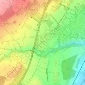
Name: Eysins topographic map, elevation, terrain.
Location: Eysins, District de Nyon, Vaud, 1262, Switzerland (46.37019 6.18787 46.39034 6.22288)
Average elevation: 445 m
Minimum elevation: 385 m
Maximum elevation: 505 m
Thank you for supporting this site ❤️
Make a donation
Make a donation
Gear up for your next adventure:
🆘Personal Locator Beacons (PLB) - Satellite emergency beacons for life-saving help in areas with no mobile coverage
As an Amazon Associate, this site earns from qualifying purchases at no extra cost to you.
Other topographic maps
Click on a map to view its topography, its elevation and its terrain.