Geolocate

Shuanglang Town topographic map

Click on the map to display elevation.

About this map
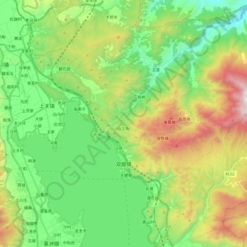
Name: Shuanglang Town topographic map, elevation, terrain.

Location: Shuanglang Town, Dali City, Dali Bai Autonomous Prefecture, Yunnan, 671009, China (25.85063 100.16442 26.04135 100.35126)

Average elevation: 2,152 m

Minimum elevation: 1,603 m

Maximum elevation: 3,244 m

Other topographic maps

Click on a map to view its topography, its elevation and its terrain.
兰峰

China > Yunnan > Dali City

Average elevation: 3,539 m

Dali Museum

China > Yunnan > Dali City > Dali Town > 大纸坊

Average elevation: 2,042 m

Gear up for your next adventure:

🚁Camera Drones with GPS - Capture aerial views of the landscape to compare with topo maps
🥾Heavy Duty Hiking Boots - Ankle-supporting boots for carrying heavy packs on steep contours
🔋Solar Power Banks - Solar chargers for outdoors
🧳Outdoor Travel Organizers - Gear organization accessories
👄SPF Lip Balm - Prevent sun and wind-burnt lips on mountain ridges

As an Amazon Associate, this site earns from qualifying purchases at no extra cost to you.